Destination Maine: The Tranquil Beauty of Bailey Island
Bailey Island draws summer visitors who already know or will discover its quiet solitude with ample opportunities to enjoy the uniqueness of Maine life.
The remote, tranquil setting of Bailey Island, Maine is far removed from boisterous vacation places, yet not enormously distant from more populous areas. Located on Casco Bay on the state’s mid-coast, some 15 miles south of Brunswick (home to Bowdoin College) and within easy drives to Boothbay Harbor or Camden, it is part of the Harpswell peninsula that also includes Great Island (whose formal name is Sebascodegan Island), Orr’s Island, and many small islands.
Once reachable only by steamship, Bailey Island is connected to the mainland by the historic Cribstone Bridge from Orr’s Island built in the late 1920s by joining granite bricks to withstand the daily tides. A new replacement bridge was constructed after the erosion of the old bridge.
Cribstone Bridge built to accommodate rushing tides

Of the original structure, local native Nancy Orr Johnson Jensen, in her book Bailey Island Memories Pictures & Lore, wrote: “The granite was quarried in Yarmouth and Pownal, Maine and brought to the site on a barge. A railway was used to bring a crane out onto the bridge as it was being built. No mortar or cement, no steel girders, no suspension cables, and no base pillars of concrete were needed. Only the weights of 10,000 tons and the positioning of the granite slabs, laid crosswire and then lengthwise, was necessary to hold the bridge together. The cribstone fashion allowed the rushing tides to flow through.”
Seeing the region by water
The island, which is less than three miles long and under one mile wide, is quintessentially New England with its coves, bays, and inlets. It has one of the most commonly photographed spots in Maine – Mackerel Cove, with its many sailing, lobster, and other fishing vessels owing to the number of working lobster men there. Mackerel Cove was where visitors arrived by boat, sometimes coming from Portland, Boston, or New York in the summer, before the Cribstone Bridge was built.
Bailey Island also draws a number of artists who come to paint its landscape of vistas, sandy beaches, boats, rocky coastal shoreline, and views of the ocean from open fields.
Land’s End, at the southernmost tip of the island, has both a small rocky beach and an adjacent gift shop with Maine souvenirs. The location has a clear view of the ocean and offshore islands. By the gift shop is the Bronze Fisherman’s Statute, paying tribute to everyone who has ever earned their living on the sea.
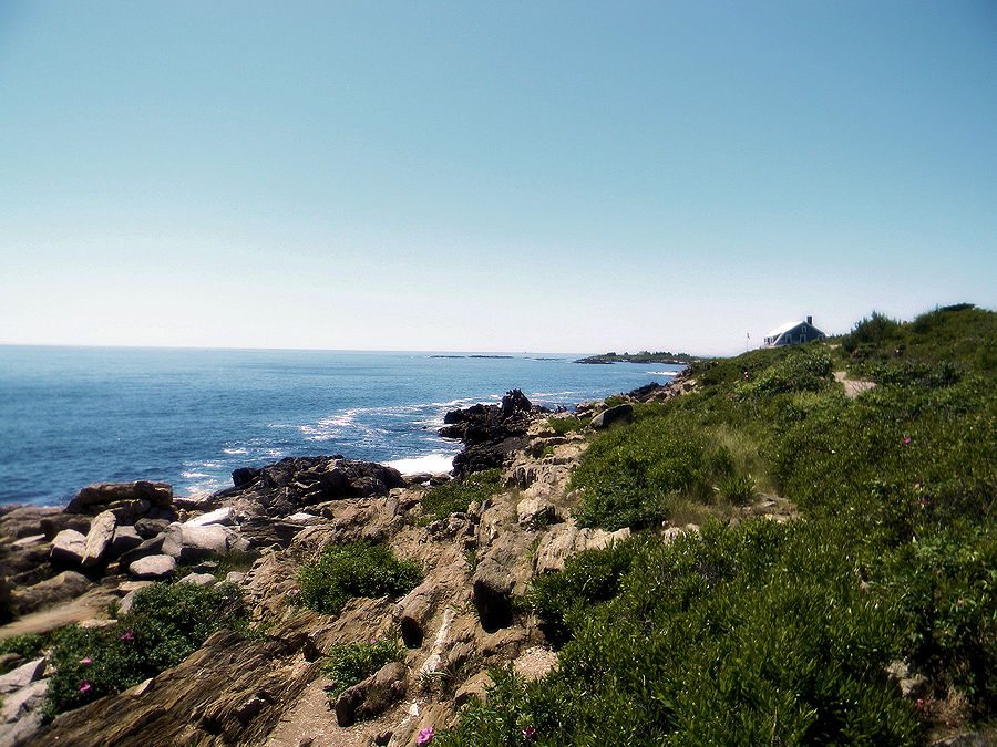
For a seaside hike on the eastern edge of the island, one often taken trip is on the Giant Stairs Trail, a rock formation resembling a large flight of stairs. The steps are evenly cut by nature out of the solid cliff. It is possible there to view the surf breaking on the ledges below.
Efforts underway to secure public access to beach
Some information on Bailey Island cites Cedar Beach as being the best on the island, but difficult to reach for the general public. Only nearby houses have the easiest access. The directions to it from Route 24 that runs the length of the island are to take Robin Hood Road to the east and follow it to the juncture with Cedar Beach Road. Drivers must park on the right side of the road before this point and walk down Cedar Beach Road to take a small marked path to the beach.
Information on visiting Bailey Island: http://www.thedriftwoodinnmaine.com/bailey_island.html